10 Innovative Ways Tech Is Revolutionizing Urban Planning
Urban planning is a complex and yet most important thing to plan the needs of all citizens now and in the future.
It includes predicting population growth, zoning, geographic analysis, or even surveying the water supply to ensure a high quality of life.
Urban planning is probably the best way to ensure the maximum level of economic development in a city, with wise management of natural resources.
Also, learn about QR Code Technology in this guide. And just as Edwin Lutyens (An architect) beautifully expressed…
“There will never be great architects or great architecture without great patrons.”
However, patrons are not the only contributors to urban planning. Hang with us to discover how tech and innovation are revolutionizing urban planning.
Let’s start!
GIS Mapping Technology
Geographic Information Systems (GIS) is a computer-based tool that enables mapping and visualizing the benefits offered by the land.
GIS technology allows architects to analyze the population density, assess environmental effects, and identify the perfect location for the project.
Additionally, to leverage the GIS technology, professionals are also referring to online masters in GIS to deepen their understanding of complex urban challenges.
Predictive Analytics for Growth Management
Predictive analytics is a powerful tool that is often used to estimate the city’s population growth, infrastructure needs, and economic growth. This also plays a crucial role in identifying the system failure and ensuring timely repair before the system breaks.
Here’s how predictive analytics improves urban planning:
- Optimize resource allocation: Predictive analytics helps planners accumulate data from various sources such as surveys, sensors, and historical records. And then predict the demand and supply of resources like water waste management and energy, ensuring optimal resource allocation.
- Enhance mobility and accessibility: It helps urban planners to design a perfect transportation system based on the data they have acquired.
- Reduce environmental impact: Predictive analytics can reduce the environmental effects during urban planning by utilizing the data from various environmental sensors, satellite imagery, and climate models.
- Increase citizen engagement: Another benefit of predictive analytics is to increase citizen engagement through their active participation in the urban decision-making and governance process.
Energy Management System
EMS or energy management system refers to the automation system that collects energy measurement data from a diverse field and makes it available for users through graphics, online monitoring tools, and energy quality analyzers.
This includes proper management of energy resources such as solar and wind while reducing carbon footprints. Which further helps the city’s greenhouse gas emissions.
Cloud technology
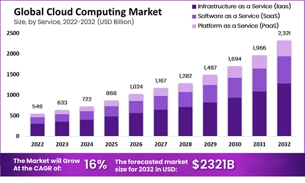
Cloud technology offers several key advantages, making it ideal for smart city initiatives. It helps planners to create data and receive information about certain areas. This also establishes a solid foundation for the adoption of forward-thinking solutions to improve urban living.
Here are some of the use cases of loud technology in urban planning:
- Smart infrastructure management
- Intelligent transportation systems
- Energy management and sustainability
- And Public safety or emergency response

Drones for Data Collection
Ariel technology has been booming in recent years, it has been making significant strides in urban planning by providing fast data collection.
It can quickly capture high-resolution images or 3D models of the urban environment, making it a cost-effective and comprehensive way to accumulate data.
Here are the top benefits of using drones in urban planning:
- More efficient inspections
- Conducting scientific research
- Rescue operations
- Creating a visual representation of the city
- And, video or photo capture for updates
Computer-Aided Design (CAD) Software
In the realm of urban planning, CAD is used to create, modify, and optimize the design. This allows planners to visualize complex cityscapes with perfect accuracy.
It is a novel advancement that assists in the illustration of urban architecture and infrastructural constructions. CAD provides perfect tools to theoretically plan the visual format of an infrastructure before any real implementation.
Augmented Reality and Virtual Reality
The seamless integration of AR and VR technology is making some groundbreaking changes in the way we plan and design a city. This helps urban planners to create 3D visuals of the building and then further use them to better understand the spatial relationships and identify the flows in the design.
Do You Know?
According to Statista, the AR & VR market is estimated to grow by 9.64% between 2024 and 2028, which may result in a volume of $58.8 billion by 2028.
Building Information Modeling (BIM)
BIM is another technology that is playing a major role in revolutionizing urban planning. This involves creating a digital model of an infrastructure and providing detailed information. The information then can be accessed throughout the project to reduce the margin of errors and plan to the highest standards.
Blockchain technology
Decentralized technology like blockchain is making waves in various industries, including urban planning. This is often used to create a secure and transparent system, making sure that the stakeholders have access to all the information they need.
Here’s how blockchain helps in sustainable urban planning:
- By providing transparency and traceability
- Decentralization for efficiency
- And, smart or self-executing contracts for governance
Internet of Things (IoT)
IoT sensors are used to create and collect data on traffic, air quality, and other metrics that help urban planners to make informed decisions regarding infrastructure development. By harnessing the power of IoT urban planners can ensure the highest quality of life for their citizens and create a more connected future for everyone.
Conclusion
In closing, technology, and innovations are not only reshaping the urban landscape but are also emerging as helpful tools in redefining the very essence of urban living. It promises a future where urban life is not only intelligent but also more inclusive, sustainable, and humane.
